Hualapai Mountain Park History
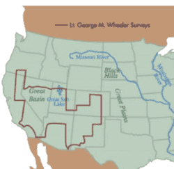
Hualapai Mountain Park is the oldest park in Mohave County. The parks early history can be traced back as far as the 1800’s. As documented in the original 1937 history portion of the Hualapai Mountain Park Master Plan, in 1871, just outside the parks boundary, was the headquarters for Lieutenant George Wheeler as he conducted one of the earliest Government Surveys in the vicinity. As shown in Exhibit 1, Lt. Wheeler explored and re-surveyed land west of the 100th meridian from the years 1871 to 1879.
The 1937 Park Master Plan, states how in 1871 Lt. Wheeler documented that the Hualapai Mountain District was actually first known as the Sacramento District. Lt. Wheeler reported that the early parties were driven out by Indians and that it was not until 1871 prospectors were able to re-enter the Hualapai Mountains when mining operations were deemed safe. Lt. Wheeler’s cabin stood in its original location for over 50 years and was still standing during the beginning of Hualapai Mountain Park in 1937.
Beginning of a Park
The 1937 Hualapai Mountain Park Master Plan provides an amazing historical background to how the Hualapai Mountain Park first began. The first noticeable difference is the spelling of Hualapai. In 1937, Hualapai was spelled Hualpai, however soon after, the United States Geological Survey (USGS) corrected the spelling.
The plan writes about Charles Metcalf, a 43 year resident of Kingman, who was considered the father of Hualapai Mountain Park. According to the Master Plan’s background, Mr. Metcalf first visited the areas of Hualapai Mountain Park in 1897. Mr. Metcalf writes that he, like many others, spent summers in the beautiful scenery and cooling breezes of the highest altitude of this section of Arizona. Mr. Metcalf noted that he read an old newspaper article stating how President McKinley would favor every community having a section of government land for recreation purposes. Based on President McKinley’s suggestions, in 1929 Mr. Metcalf wrote Arizona Senator Haden with the interest of selecting Section 20 as a desirable purpose for a park.
Section 29, directly south of Section 20 was also a popular spot and was called the “scenic heart of the Park in the 1937 Master Plan. Section 29 was originally deeded to the Kingman Country Club by the Santa Fe Railroad Company. On October 19, 1929, Section 29 was deeded over to Mohave County from the Kingman Country Club.
Section 20 was set aside by Congress in 1934, creating the way for Mohave County to acquire the land for recreational purposes. Soon after Section 20 was set aside, Section 29 and 30 were acquired when the 74th Congress passed House Bill 8172 (Public Law 457)
It was during the 1930’s, when the Depression-era Civilian Conservation Corps (CCC), part of President Roosevelt’s New Deal Program, set up camps in the Hualapai Mountain to build roads, cabins, restrooms, kitchen buildings, water systems and other improvements.
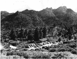
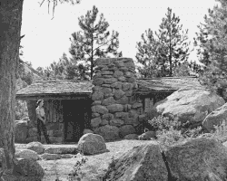
During the year 1937, Mohave County Purchased 8.6 acres of land at the SW ¼ of Section 21 to ensure the completion and protection of the community building and picnic area, also known as Rec. 1 today. Pictured in Exhibit 3 is Rec. 1 taken in 1937.
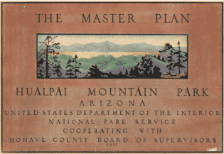
In 1937, the United States Department of Interior - National Park Service cooperating with Mohave County Board of Supervisors prepared the first Hualapai Mountain Park Master Plan.
Once considered a candidate for National Monument status, then rejected as a potential Arizona state park, Hualapai Mountain was turned over to Mohave County in 1939 for "public park, recreational and other municipal purposes," by Patent from the General Land Office, signed by Franklin D. Roosevelt.
By 1940, the final land total for Hualapai Mountain Park consisted of:
- Section 20 totaling 536 acres.
- Section 21 totaling 8.6 acres.
- Section 28 totaling 400 acres.
- Section 29 totaling 640 acres.
- Section 30 totaling 640 acres.
All sections combined totaled 2,226.6 acres, which is still the current acreage today, 82 years later. In the 1940’s, more than a dozen new wood cabins were constructed in addition to the original stone cabins build in 1936 by the Civilian Conservation Corps.
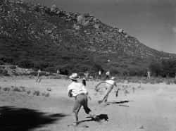
Davis Camp Park and Hualapai Mountain Park have shared a long history of being affiliated with each other. During construction of Davis Dam in the late 1940’s, the Dam employees would recreate at Hualapai Mountain Park. As shown in Exhibit 6, is a picture taken in 1948 of the Davis Dam Employees playing baseball at Hualapai Mountain Park Rec. 1
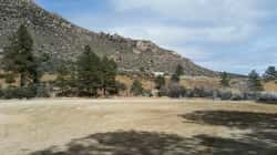
Today, 71 years later, as shown in Exhibit 7, the ball field still exists next to Rec. 1 and is used for special events and additional parking.
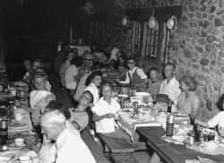
Pictured in Exhibit 8 is a photo taken in 1948 of Davis Dam employees and families having dinner in Rec. 1.

Today, Rec. 1 is still used almost every weekend for special events. Exhibit 9 is a photo of Rec. 1 during winter wonderland.
Contact Us
Mohave County Parks
Book Now
(877) 757-0915